 Fraunhofer Institute for Industrial Mathematics ITWM
For many years, we have been developing methods for the analysis of geo-referenced data, supporting, and improving the virtual development, testing and validation of vehicle systems. In the context of a steadily increasing complexity of the assistance and automation functions used in vehicles, classical testing and design methods are more and more reaching their limits. Virtual approaches, simulation-based methods and scenario-based validation are becoming increasingly important and have already become an indispensable part of the modern development process.
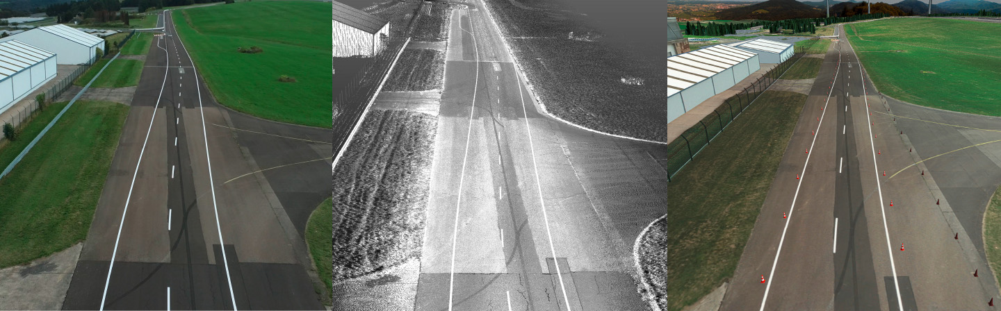
Left: Aerial view of an automotive proving ground Center: Three-dimensional raw point cloud data Right: Virtual 3D scene of the proving ground
Virtual Environments for Developing, Testing, and Validating Autonomous Vehicle Functions
VMC® Road & Scene-Generator
Efficient Simulation Requires Realistic Virtual Environments
Current approaches to generating digital environment data for simulation often fail to reproduce the variability and heterogeneity of the »real« world. Real assistance systems, however, must be able to ensure a safe driving state in any situation. This must be considered early in the development process and integrated into the simulation.
The software package »VMC® Road & Scene-Generator« developed at Fraunhofer ITWM enables the virtual development and testing of automation systems based on real environmental data – as part of the software suite VMC® Virtual Measurement Campaign.
Multi-Level Generation of Environment Models
Depending on the requirements and application, VMC® Road & Scene-Generator offers different levels of resolution and detail.
The focus is on the generation of environment models as a digital representation of real, public roads or proving grounds based on high-precision measurement data, such as those generated by the institute's own measurement vehicle REDAR (and optional additional drone). The processing of these data with the VMC® Road & Scene-Generator offers the following advantages:
- Millimeter-precise capture of the surrounding area by laser scanners and color imaging cameras.
- Surface models and excitations for system simulation and driving simulators
- Digital map material
- Photorealistic 3D representations for modern graphics engines
But even without highly accurate measurement data, the VMC® Road & Scene generator can generate realistic environments and thus contribute to simulation-based vehicle development. The following options are available here:
1. abstract input information, such as the semantic description of traffic networks, can be provided quickly and globally available from the VMC® database as input for the simulation
2. complex, detailed and realistic three-dimensional scenes for the simulation of sensors (camera, LiDAR, radar, ...) and assistance systems can be generated additionally from the fusion of different available data sources.
By using the VMC® Road & Scene Generator, virtual worlds are created that provide the optimal combination of variability, degree of realism and costs for each application.
Digital Twin of Proving Grounds
As an example of a possible use case of the VMC® Road & Scene-Generator, you can interactively experience TRIWO's Automotive Testcenter Pferdsfeld in the web demo.
Automated processing of the measured data (REDAR data and drone data) enables us to capture real environments and generate a digital version as a 3D environment. The virtual world generated in this way has a very good fit with the surface model in the track area and allows drivers to immerse themselves in the world in the RODOS driving simulator.
With the keys W,A,S,D or the arrow keys you can determine the driving direction.
With the shift key you can speed up, with Strg/Ctrl you can slow down.
With the right mouse button you can look around.
If you have problems with the display, you can open the demo scene in a new window.